|
|
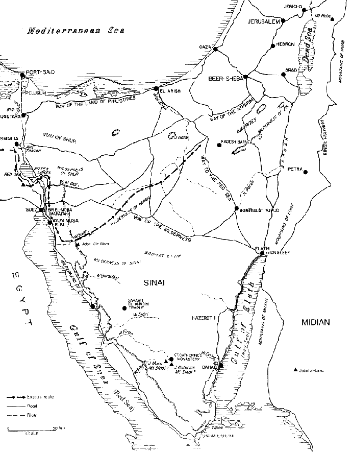
| March 1, 2001 Thoughts on Jebel al-Lawz and the Location of Mt. Sinai (Extracted from the editorial in Bible and Spade, Fall 2000) Bryant G. Wood There has been much publicity in recent years concerning the identification of Jebel al-Lawz as Mt. Sinai. Although this idea is not new, it has been given new life by two adventurers, Robert Cornuke and Larry Williams. Although present knowledge does not allow us to pinpoint the exact position of Mt. Sinai, we can ascertain its general location from data given in the Bible. The Bible tells us exactly how long it took the Israelites to travel from Mt. Sinai to Kadesh Barnea. Knowing their approximate rate of travel provides a rough calculation of the distance traveled. This places Mt. Sinai in the general area of the northern Sinai Peninsula, not in Saudi Arabia. Scholars have paid scant attention to this important information in their efforts to locate Mt. Sinai.
Individuals traveling in the Sinai on camelback average about 20 miles per day, or a little less (Davies 1979: 95-96). Donkey and camel caravans can average between 16 and 23 miles per day (Davies 1979: 96; cf. Beitzel 1985: 91), depending upon the terrain. Early in the 15th century BC, the Egyptian army under the leadership of Tuthmosis III averaged a com-mendable 15 miles per day in traversing the relatively easy coastal route from the eastern border of Egypt to Gaza (Wilson 1969: 235, n. 16). Once they left Gaza, however, and began to negotiate the rugged terrain of central Canaan, their rate decreased to 7 miles per day (Wilson 1969: 235, n. 18). We have another record of a long journey made by a large number of people in Biblical times. This was the trip made from Babylon to Jerusalem by Ezra and a group of Jews returning from Exile. They left Babylon on the 12th day of the first month (Ezr 8:31) and arrived in Jerusalem on the first day of the fifth month (Ezr 7:9). The total elapsed time for the expedition was thus 121 days less 11, or 110 days. Allowing 15 days for Sabbath rest gives 95 travel days. The total distance covered was ca. 900 miles (The NlV Study Bible, note on Ezra 7:7-9), resulting in an average of 9.5 miles per day. Ezra and his company were following a well-traveled route without flocks and herds and thus were able to achieve a respectable rate of travel. A large group of pastoralists moving with their possessions and animals can cover no more than 6 miles in a day, and usually less (Conder 1883: 79; cf. Beitzel 1985: 91). The limiting factor is the animals. When the Israelites left Egypt, they had "large droves of livestock, both flocks and herds" (Ex 13:38). Adequate sources of water had to be sought for them along the way and time had to be taken to allow the flocks and herds to graze as they traveled. A crucial Biblical text for locating Mt. Sinai is Deuteronomy 1:2. Here it states that it took 11 days for the Israelites to travel from Horeb (Mt. Sinai) to Kadesh Barnea in the northern Sinai. This limits the location of Mt. Sinai to 60 or so miles from Kadesh Barnea. The straight-line distance from Jebel al-Lawz to Kadesh Barnea is approximately 150 miles. Allowing for diversions to find water, twists and turns, and ups and downs, the walking distance would be much greater. This is much too far for the Israelites to travel in 11 days. Even more devastating to the Saudi Arabia theory is the yam suph (Reed Sea) crossing. According to the Bible it occurred at the beginning of the journey shortly after the Israelites set out from Ramesses (Ex 12:37; 13:20-14:2; Nm 33:5-8). The Saudi Arabia theory places the yam suph cross-ing near the end of the journey at the Strait of Tiran at the southern end of the Gulf of Aqaba, some 350 map miles from Ramesses. There is no way the Israelites could have reached the Strait of Tiran within a few weeks after having left Egypt. The traditional site of Jebel Musa cannot be Mt. Sinai either. The distance from Jebel Musa to Kadesh Barnea is about 160 map miles, again much too far for the Israelites to trek in 11 days. Utilizing the travel time of the Israelites as an estimate of the distance traveled, the location of Mt. Sinai should be sought in the northern area of the Sinai Peninsula, roughly 60 miles from Kadesh Barnea.
|